A History of Aerial Topographical Surveying – From Aircraft Photography to Drone Mapping
Aerial surveying has revolutionized how we map our world. What began with photographs taken from airplanes now involves advanced drones capturing high-resolution 3D data. This transformation has significantly improved how we plan infrastructure, monitor terrain, and manage land — especially in mountainous regions like Nepal.
In this post, we explore the evolution of aerial surveying, comparing historic methods with modern drone technologies, including technical details, equipment, data outputs, and how these tools are used in Nepal today.
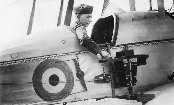
1. The Early Era: Aerial Photography from Aircraft (1920s–1980s)
Aerial surveying began during World War I, when military forces first used aircraft to capture images of enemy terrain. This practice quickly gained popularity in civil engineering, urban planning, and topographic mapping.
Key Milestones:
1920s–1930s: Governments and engineers began using aircraft-mounted cameras to map cities, farmlands, and rivers.
1950s: Aerial photography became a common method for topographic map creation, especially in rugged or inaccessible areas.
While effective, this method had limitations: it was expensive, weather-dependent, and required skilled pilots and heavy equipment.
How It Worked
In the early 20th century, cameras were mounted on airplanes that flew grid patterns, capturing overlapping images. These were analyzed using stereoscopes to produce 3D terrain models and contour maps.
Technical Specifications
Cameras: Zeiss RMK, Fairchild K-17 (large-format, analog cameras)
Aircraft: Cessna 206, de Havilland DHC-2
Film Type: Panchromatic rolls
Flying Altitude: 1,000–5,000 meters
Scale: 1:25,000 to 1:50,000
Output: Paper-based topographic maps, contour lines, orthophotos
Limitations
Weather dependency
Expensive flights and film processing
Limited resolution and accuracy (~1–3 meters)
Labor-intensive photogrammetry using analog stereo plotters
2. The Satellite Era: Remote Sensing from Space (1970s–2000s)
 Overview
 Overview
With the launch of satellites like Landsat in the 1970s, aerial surveys became possible without taking to the skies. Satellite imagery provided broader coverage with multispectral capabilities.
Technical Insights
Satellites: Landsat, SPOT, IRS, WorldView
Sensor Resolution:
Early: 30m (Landsat)
Modern: 0.3m (WorldView-3)
Data Types: Multispectral, hyperspectral, thermal
Software Used: ENVI, ERDAS Imagine, ArcGIS
Common Outputs: Land use maps, NDVI vegetation analysis, regional base maps
Pros and Cons
Pros:
Wide-area coverage
Frequent revisit cycles
Useful for environmental monitoring
However, satellite imagery lacked the high spatial resolution needed for many construction and cadastral projects. This paved the way for the next big leap — Unmanned Aerial Vehicles (UAVs).
Cons:
Lower spatial resolution than drones
Affected by cloud cover
Not ideal for detailed engineering or cadastral work
3. The Modern Revolution: UAV Drone Surveying (2010s–Present)
Over the last decade, UAV drones have completely revolutionized aerial surveying. Compact, cost-effective, and equipped with LiDAR, multispectral, or high-resolution cameras, drones provide unmatched detail and flexibility.
What Changed?
Drones (UAVs) introduced low-altitude, high-resolution aerial surveying with GPS precision. They made surveying faster, safer, and more accessible in areas with difficult terrain — like Nepal.
Why Drones Are a Game-Changer:
Affordability: No need for aircraft charters or satellite access
Precision: High-resolution 2D and 3D data from low altitudes
Speed: Survey large or remote areas quickly
Safety: Minimal risk in hazardous terrain
In Nepal, drones are now widely used in:
Road and hydropower planning
Post-disaster mapping (landslides, earthquakes)
Urban development and cadastral mapping
Forestry and conservation
Types of Drone Surveys
A. Photogrammetry Drones
Example Models: DJI Phantom 4 RTK, WingtraOne GEN II
Camera Resolution: 20 MP
Accuracy: ±3–5 cm (with RTK GNSS)
Flight Altitude: 60–120 m AGL
Coverage: 100–400 ha per day
Processing Software: Pix4D, Agisoft Metashape, DroneDeploy
Outputs:
Orthomosaic images
Digital Surface Models (DSM)
3D point clouds
Contour lines
Volume analysis
B. LiDAR-Enabled Drones
Example Models: DJI Matrice 350 + Zenmuse L2, RIEGL miniVUX
Laser Points: 240,000–1 million points/sec
Vertical Accuracy: ±2–5 cm
Advantages: Penetrates vegetation, better in forested or uneven terrain
Software: LAStools, Global Mapper, TerraScan
Outputs:
Bare-earth Digital Terrain Models (DTM)
Classified point clouds
3D topography for engineering design
4. Comparing Aerial Surveying Methods
| Feature | Aircraft Survey | Satellite Imagery | UAV Drone Survey |
|---|---|---|---|
| Resolution | ~1–3 m | 0.3 m – 30 m | 1–5 cm (photogrammetry) |
| Cost | High | Medium | Low to Medium |
| Accuracy | ±1–3 m | ±5–10 m | ±2–5 cm (with RTK) |
| Data Turnaround | Weeks to Months | Days | Hours to 2–3 Days |
| Vegetation Penetration | No | No (optical only) | Yes (LiDAR-equipped) |
🏔️ Nepal’s Adoption of Drone Surveying
Due to its mountainous terrain and remote villages, Nepal has quickly embraced drone surveys. Leading firms like R.R.P. Survey Consults Pvt. Ltd. use UAVs for:
Topographic and engineering surveys
Digital Elevation Model (DEM) creation
LiDAR-based terrain analysis
Road alignment and construction monitoring
Drone data is also being integrated with GIS systems, helping planners make better, faster decisions.
5. Aerial Surveying in Nepal: Local Applications
Nepal’s unique topography — including hills, valleys, and flood-prone plains — makes drone surveys especially useful. Government projects, infrastructure planning, and hydropower alignments now often rely on UAV data.
Due to its difficult terrain, Nepal has quickly adopted UAV surveying for:
Infrastructure: Road alignment, hydropower planning
Urban Development: Topographic mapping in Kathmandu, Pokhara
Disaster Response: Landslide mapping, post-earthquake reconstruction
Forestry: Deforestation monitoring, canopy density analysis
Case Examples:
Upper Tamakoshi Hydropower: Used drone and LiDAR for terrain modeling and road alignment
Post-earthquake mapping (2015): UAVs mapped damaged zones for reconstruction planning
Urban Planning in Pokhara and Kathmandu: High-res orthomosaics and 3D models produced via drone survey
Engineers used drone and LiDAR surveys to map steep terrain for road construction, tunnel alignment, and water flow analysis — saving time and reducing field risks.
🔗 Related reading: How drones improve mapping in South Asia – World Bank
6. Conclusion
From manual photogrammetry to real-time drone mapping, aerial surveying has become faster, safer, and more accurate. In Nepal’s diverse landscapes, UAVs have become essential tools for engineering, disaster planning, and urban development.
If you’re planning a project and need reliable terrain data, now is the time to embrace modern drone surveying.
Work with Nepal’s Drone Survey Experts
At R.R.P. Survey Consults Pvt. Ltd., we combine decades of surveying experience with cutting-edge drone and LiDAR technology.
Our Services Include:
Topographic and engineering surveys
Drone photogrammetry and LiDAR mapping
Cadastral and GIS-ready datasets
3D modeling and terrain analysis
📍 Kathmandu, Nepal
☎️ Landline: +977-1-5107618
📱 Mobile: 9849875800
🌐 Website: www.rrp.com.np